Regulatory Alignment & Submission Support

Drone-acquired Aerial Imagery and Video for Regulatory Alignment

In the Rocky Mountain region, a permit application is only as strong as the data behind it. Whether you are working with the BLM on an APD or navigating USACE wetlands requirements, the agencies aren’t just looking for information, they are looking for conformance. If your maps don’t meet their specific digital standards, your project sits on a desk while costs climb.

At Grouse Mountain Environmental Consultants, our Regulatory Alignment & Submission Support team acts as the bridge between your project goals and agency expectations. We ensure that your spatial data is a “digital handshake”: perfectly formatted, technically sound, and ready for approval.

Mapping Built for Compliance

Federal and state permitting requires more than just a site plan; it requires a specialized suite of maps that address distinct environmental concerns. We provide comprehensive mapping support tailored to the specific requirements of:

  • Applications for Permit to Drill (APD): Precise site layouts including access roads, pad locations, and resource offsets.

  • Rights-of-Way (ROW): Detailed routing across federal, state, and private lands, ensuring all buffers and boundaries are respected.

  • Reclamation Plans: Visualizing the roadmap from initial disturbance to final bond release, ensuring the WDEQ or other state agencies see a clear path to success.

Navigating the “Standard” Maze

Every agency has its own “language” of data. A file that works for the USFWS might not meet the technical metadata requirements of the USACE or WDEQ. We specialize in cross-agency conformance, ensuring your project aligns with:

  • BLM & USFS Standards: Strict adherence to spatial data management and resource protection buffers.

  • USFWS & State Wildlife Agencies: Mapping that accounts for T&E species, raptor nests, and seasonal timing stipulations.

  • Clean Water Act Compliance: USACE-ready delineations and impact maps that facilitate Section 404 permitting.

Frictionless Data Delivery Packages

The final hurdle of any permitting effort is the delivery. Modern agencies often require specific file formats (like File Geodatabases or specific CAD layers) accompanied by detailed metadata.

We don’t just send you a map; we provide a complete Data Delivery Package. These packages are built to plug directly into agency systems, reducing the need for “clarification” requests and administrative back-and-forth. When the agency receives a GMEC package, they know the data is clean, the coordinates are correct, and the standards are met.

The GMEC Difference

Regulatory alignment isn’t just about following rules; it’s about understanding the nuances of the region. Because we are based in the West and work with these agencies every day, we know how to anticipate their questions and address them through our mapping before they ever become “bottlenecks.”

Ready to ensure your project’s compliance?

Contact Grouse Mountain Environmental Consultants today for a consultation.
Learn more about our GIS Mapping, UAS, and Database solutions.

Environmental Reporting & Data Visualization

3D Modeling and Spatial Analysis for environmental reporting

If you’ve ever sat through a project meeting with a 50-page spreadsheet, you know that data isn’t always easy to digest. In environmental reporting, the real challenge isn’t just collecting the data, it’s communicating what that data means to regulators, stakeholders, and construction crews.

At Grouse Mountain Environmental Consultants, we believe that a great deliverable should tell a clear story. Our Environmental Reporting and Visualization team bridge the gap between technical field data and the high-level visuals you need to keep your project moving.

Stakeholder-Ready Maps: Print & Digital

Different stakeholders have different needs. A BLM field officer might need a high-resolution PDF for an APD package, while your internal team needs an interactive digital map to track daily progress.

We produce professional map products tailored for every audience:

  • Federal & State Submissions: We ensure every map meets the rigid formatting and data standards required by agencies like the BLM, USFS, and NMED.

  • Internal Planning: Clear, high-contrast layouts that help your team visualize terrain, access roads, and environmental constraints at a glance.

  • Public Outreach: Visuals designed to simplify complex ecological data for landowners or tribal partners.

Interactive Dashboards: Real-Time Insights

Sometimes a static map isn’t enough. For projects with many moving parts, like multi-well pads or large-scale infrastructure, we build custom dashboards.

These visualizations allow you to interact with your data in real time:

  • Compliance Tracking: Instantly see which sites have passed inspection and which need attention.

  • Progress Monitoring: Track reclamation success or survey completion percentages through intuitive charts and live maps.

  • Centralized Access: No more digging through emails; your project’s health is visible in one secure, digital location.

The Final Word: As-Built & Post-Construction Mapping

The work doesn’t end when the construction stops. Accurate As-Built Mapping is a critical final step for regulatory close-out and long-term liability management.

We provide the “final record” of your project, documenting:

  • Actual Disturbance vs. Planned: Proving that construction stayed within the permitted footprint.

  • Infrastructure Placement: Precisely mapping the final location of pipelines, pads, and facilities.

  • Reclamation Boundaries: Setting the baseline for future monitoring and bond release.

The GMEC Difference

Our deliverables aren’t just an “extra step”—they are the tools that secure your permits and protect your reputation. By combining “boots-on-the-ground” field data with advanced visualization, we make sure your project is seen in the best possible light.

Ready to ensure your project’s compliance?

Contact Grouse Mountain Environmental Consultants today for a consultation.
Learn more about our GIS Mapping, UAS, and Database solutions.

Field Data Collection & Mobile Tools

gis and database solutions for Field Data Collection

In the field, things move fast. Whether you are navigating a remote basin in New Mexico or conducting raptor surveys in the Wyoming high country, the old way of doing things (paper maps, handwritten notes, and manual data entry back at the office) just doesn’t cut it anymore. It’s slow, it’s prone to human error, and it creates a massive bottleneck between the field and the final report.

At Grouse Mountain Environmental Consultants, we’ve replaced the clipboard with high-accuracy, GPS-enabled mobile tools. By digitizing the process from the very first step, we ensure that the data we collect is as precise as the projects we support.

Precision at the Source: GPS-Enabled Field Data Collection

Accuracy isn’t just a “nice to have” in environmental consulting; it’s a regulatory requirement. When we are marking the boundary of a wetland or a sensitive plant population, a few feet of error can be the difference between a compliant project and a regulatory violation.

Our field teams use ruggedized, GPS-enabled tablets that allow for sub-meter accuracy in the field. This means:

  • Immediate Spatial Context: We can see exactly where we are in relation to existing project boundaries and constraints in real time.

  • Eliminated Transcription Errors: Data is recorded digitally at the point of origin, so there’s no “deciphering” messy handwriting later.

  • Rich Data Points: We can attach high-resolution photos, audio notes, and precise coordinates directly to a single record.

Customized Tools for Specific Surveys

Environmental work isn’t one-size-fits-all, so our tools shouldn’t be either. We build and customize our own mobile platforms to match the specific survey at hand.

By using logic-driven forms, we ensure that our biologists never miss a required field. We have specialized digital workflows for:

  • Wildlife Surveys: Built-in checklists for raptor productivity or Mexican Spotted Owl protocols.

  • Compliance Tracking: Real-time logging of BMP (Best Management Practice) inspections for erosion and sediment control.

  • Wetland Delineations: Streamlined forms that automatically pull in regional plant lists and soil indicators.

Real-Time Syncing: From Field to Office in Seconds

The biggest advantage of a mobile-first strategy is speed. In the past, a project manager might wait days or even weeks for field data to be transcribed and mapped.

With our integrated systems, data is synced to the cloud as soon as a biologist gets a signal.

  1. Faster Decision-Making: If a “no-go” constraint is found in the field, the office knows about it immediately, allowing for rapid route adjustments.

  2. Dynamic Reporting: We can generate draft reports and maps almost as fast as the data is collected.

  3. Transparency: Clients can receive status updates based on real-time progress, not just “best guesses.”

The GMEC Difference

We don’t use technology just because it’s modern; we use it because it makes our work more defensible and our clients’ projects more efficient. By bridging the gap between the field and the office, we take the guesswork out of environmental compliance.

Ready to ensure your project’s compliance?

Contact Grouse Mountain Environmental Consultants today for a consultation.
Learn more about our GIS Mapping, UAS, and Database solutions.

Data Management & Integration

Development of Database Management Solutions Using Microsoft® Technologies Including Azure Cloud

In environmental consulting, we collect a lot of data. Between wildlife surveys, wetland delineations, and air quality monitoring, a single project can generate thousands of data points. But here is the reality: data is only an asset if it’s organized. If it’s sitting in scattered spreadsheets or buried in field notebooks, it’s a liability.

At Grouse Mountain Environmental Consultants, our Data Management & Integration team specializes in turning that mountain of information into a streamlined, searchable, and audit-ready system. Here is how we make sense of the noise.

One “Source of Truth”: Project-Specific Geodatabases

When multiple teams are working on a single project, biologists in the field, GIS techs in the office, and project managers in the boardroom, version control becomes a nightmare.

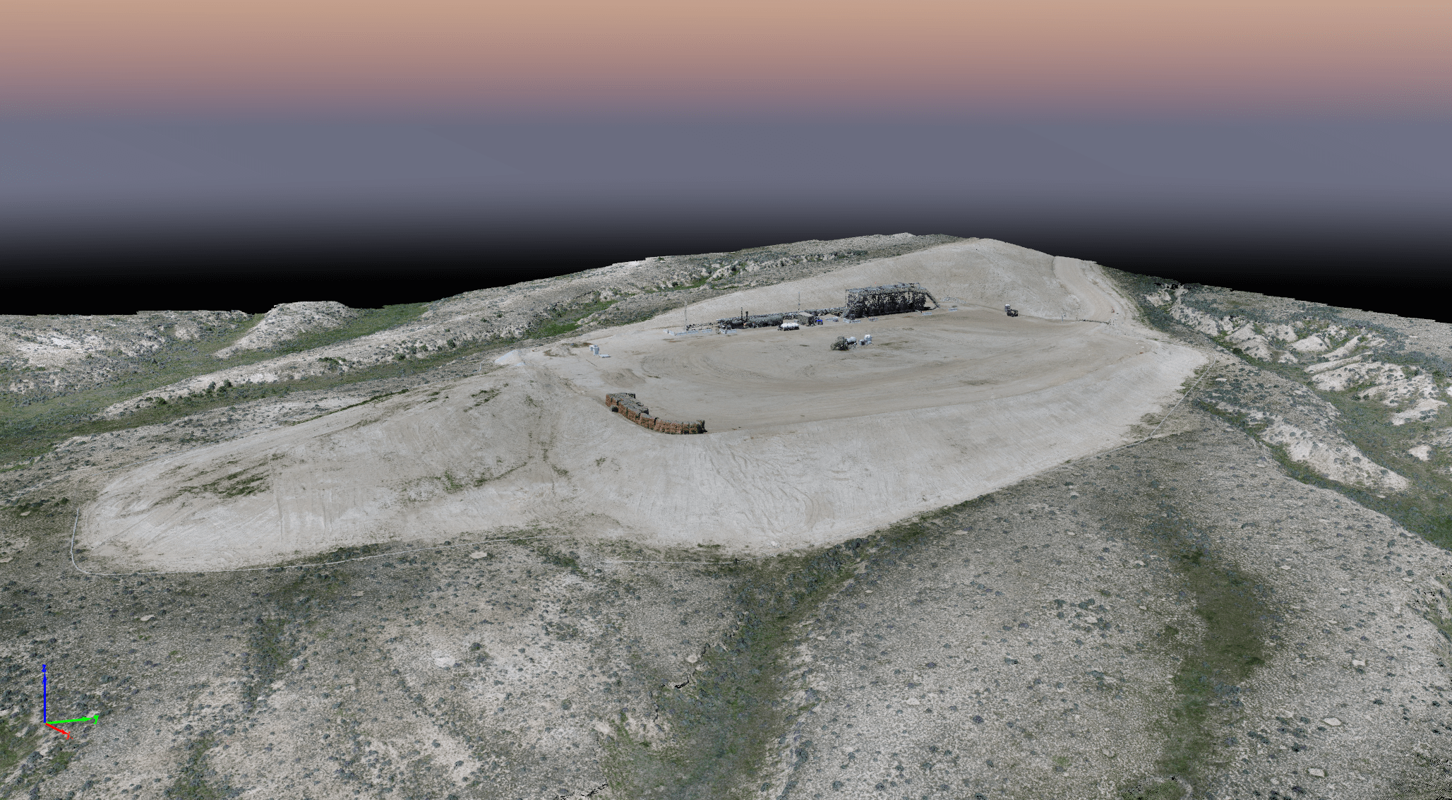
We solve this by building project-specific geodatabases. Think of this as the “brain” of your project. It’s a centralized hub where every piece of information lives. Whether it’s a GPS coordinate for a raptor nest or a soil sample result, it’s stored in one place. This ensures that everyone is looking at the same, most up-to-date information, reducing errors and saving hours of back-and-forth.

Connecting the Dots: Data Management

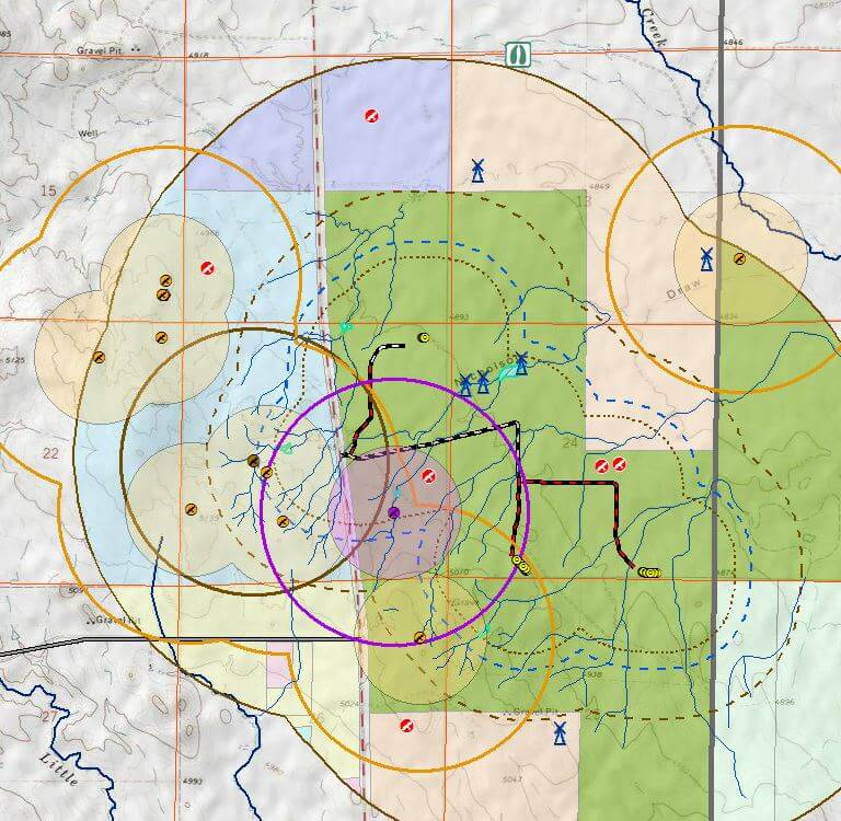
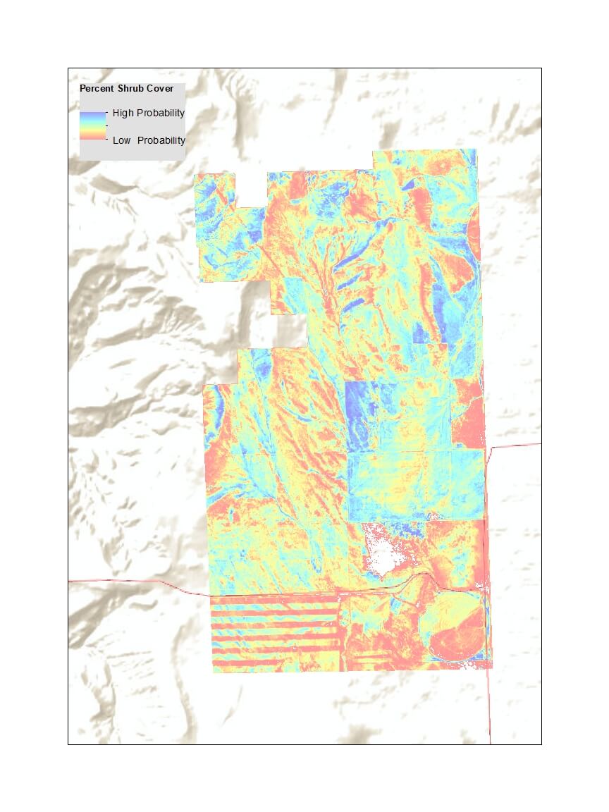
Data doesn’t exist in a vacuum. A spreadsheet of water quality results (tabular data) is much more valuable when you can see exactly where those samples were taken on a map (spatial data).

Our team specializes in Data Integration. We pull information from various sources like mobile field apps, historical records, and lab results, and stitch them together. This allows us to perform deeper analysis, such as:

  • Tracking how reclamation efforts are progressing over specific acreage.

  • Visualizing emissions trends across multiple oil and gas assets.

  • Correlating wildlife sightings with specific habitat types or construction timelines.

The Safety Net: QA/QC Processes

Regulators don’t just want data; they want defensible data. A single typo in a coordinate or a missing field in a report can stall a permit for weeks.

We treat Quality Assurance and Quality Control (QA/QC) as a core part of our workflow, not an afterthought. Our process includes:

  • Automated Validations: Ensuring data entries meet specific criteria before they ever hit the database.

  • Peer Reviews: Having senior specialists verify field data for accuracy and completeness.

  • Consistency Checks: Making sure that what was recorded in the field aligns perfectly with the final permitting documents.

The GMEC Advantage

Better data management leads to faster permits, lower costs, and zero surprises during audits. At Grouse Mountain, we don’t just hand you a stack of reports; we provide a clear, organized digital history of your project.

Ready to ensure your project’s compliance?

Contact Grouse Mountain Environmental Consultants today for a consultation.
Learn more about our GIS Mapping, UAS, and Database solutions.

Why GIS is the Most Important Field Tool You’ll Never Have to Carry

GIS Mapping, UAS, and Database Solutions

GIS mapping is more than just a picture of where a project is going, it’s the strategy that gets it there. At Grouse Mountain Environmental Consultants, we’ve learned that the difference between a project that stays on schedule and one that hits a regulatory wall often comes down to spatial data.

Whether we’re working in the high desert of New Mexico or the mountains of Wyoming, our GIS (Geographic Information Systems) team isn’t just making “pretty pictures.” We’re building the roadmaps that keep your project compliant and moving forward.

Custom Maps Designed for the Field

Generic maps don’t cut it when you’re dealing with specific permitting requirements like an APD (Application for Permit to Drill) or a complex Rights-of-Way (ROW) package. We build maps tailored to the exact variables of your site.

  • Wildlife & Habitat: We map out everything from Sage-grouse core areas to Mexican Spotted Owl PACs so you know exactly where the boundaries are.

  • Water Resources: Pinpoint WOTUS determinations and floodplains to simplify your Clean Water Act compliance.

  • Infrastructure: We layer existing pipelines, roads, and land-use data so you can see how your project fits into the existing landscape.

Spotting the “No-Go” Zones Early

One of the biggest headaches in this industry is discovering an environmental constraint after the planning phase. Our Suitability Analysis and Constraint Overlays act as a high-tech early warning system.

By stacking biological, cultural, and regulatory data, we can “see” the invisible hurdles. This allows us to:

  • Identify potential soil contamination or protected habitats before they become liabilities.

  • Optimize pipeline routes or facility locations to save time and money.

  • Ensure every move aligns with BLM, USFS, or state land-use standards.

Getting Everyone on the Same Page

Environmental work involves a lot of moving parts: landowners, tribal partners, and multiple regulatory agencies. GIS serves as the universal language.

When you can show a stakeholder a clear, accurate visual of a proposed project, it replaces confusion with confidence. Whether it’s an as-built map for final reporting or a visual planning tool for a public hearing, we make sure the data is easy to digest and impossible to argue with.

The GMEC Difference

Our GIS mapping specialists don’t work in a vacuum. They sit right next to our wildlife biologists, air quality experts, and reclamation teams. That means our maps aren’t just based on satellite imagery; they’re backed by the “boots-on-the-ground” data our teams collect in the field every day.

Ready to ensure your project’s compliance?

Contact Grouse Mountain Environmental Consultants today for a consultation.
Learn more about our GIS Mapping, UAS, and Database solutions.

GET IN TOUCH

You can find us in the office weekdays from 8am-5pm or call anytime.

P: 307.684.2112

Grouse Mountain Headquarters

760 West Fetterman Street
Buffalo, WY 82834

Grouse Mountain New Mexico

3600 Cerrillos Rd, Ste 407
Santa Fe, NM 87507

Send us a message or inquire on your next project.

  • This field is for validation purposes and should be left unchanged.