Water Quality Monitoring & Reuse Permitting

water quality monitoring

In the Mountain West, water is no longer just a utility, it is a finite asset. As regulatory pressures mount and water scarcity becomes a primary operational risk, the ability to treat, monitor, and reuse water is transforming from a “sustainability goal” into a business necessity. Whether you are managing a high-output mining operation, a power plant, or an energy development site, turning a discharge stream into a reusable resource requires a sophisticated blend of chemical analysis and regulatory strategy.

At Grouse Mountain Environmental Consultants, we provide specialized Water Quality Monitoring and Reuse Permitting. We help industrial operators navigate the transition from “disposal” to “diversification” with data-driven programs that protect both the environment and the bottom line.

Custom Monitoring for Industrial & Energy Demands

A “one-size-fits-all” sampling plan rarely survives an agency audit or a complex industrial process. We design and implement monitoring programs specifically engineered for the unique chemical “fingerprints” of your industry:

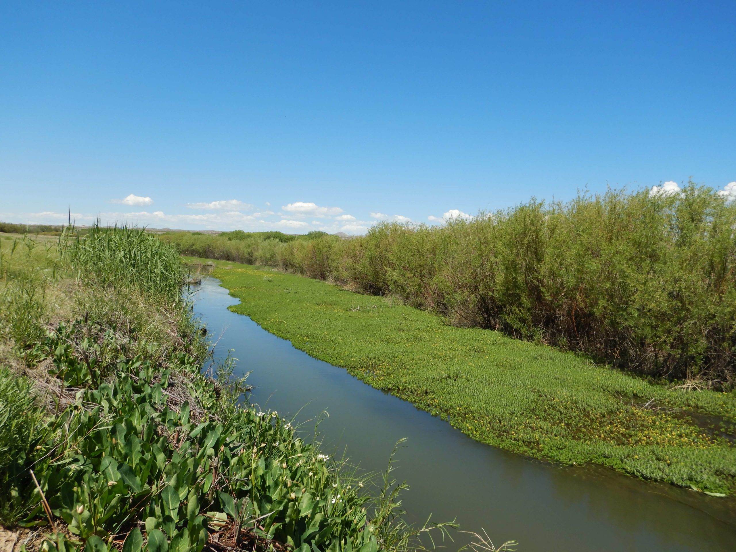
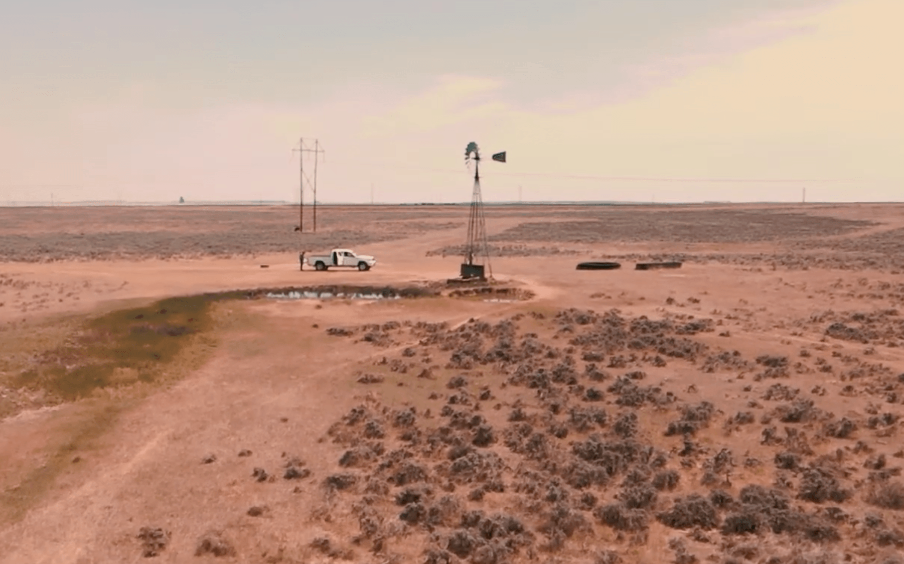
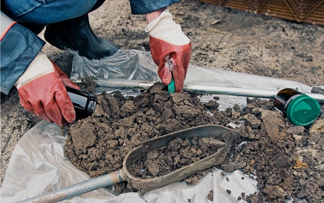
  • Mining & Industrial Monitoring: We track heavy metals, pH, and TDS (Total Dissolved Solids) in real-time to ensure your treatment systems are performing as designed and your permit limits are protected.

  • Energy-Development Support: From produced water to cooling tower blowdown, we provide the high-frequency sampling needed to characterize complex waste streams for potential reuse.

  • Baseline & Compliance Programs: We establish a rigorous “source of truth” for your water quality, providing the legal defensibility needed to manage long-term liability.

The Path to Reuse: Sampling & Permitting

The bridge between a “waste stream” and a “reusable asset” is built on documentation. We manage the full technical and administrative lifecycle of water reuse:

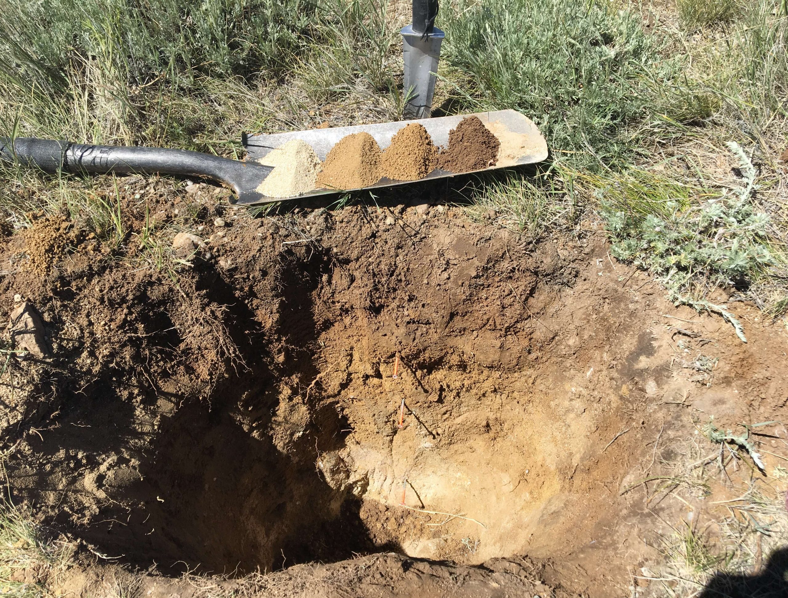
  • Effluent Characterization: We perform the intensive laboratory analysis required to prove that treated water meets the specific safety and quality standards for its intended new purpose.

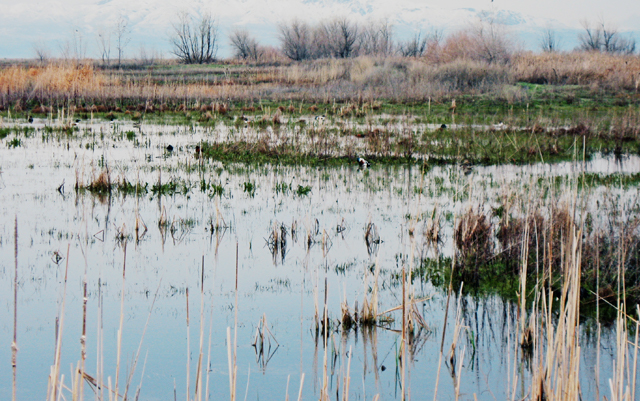
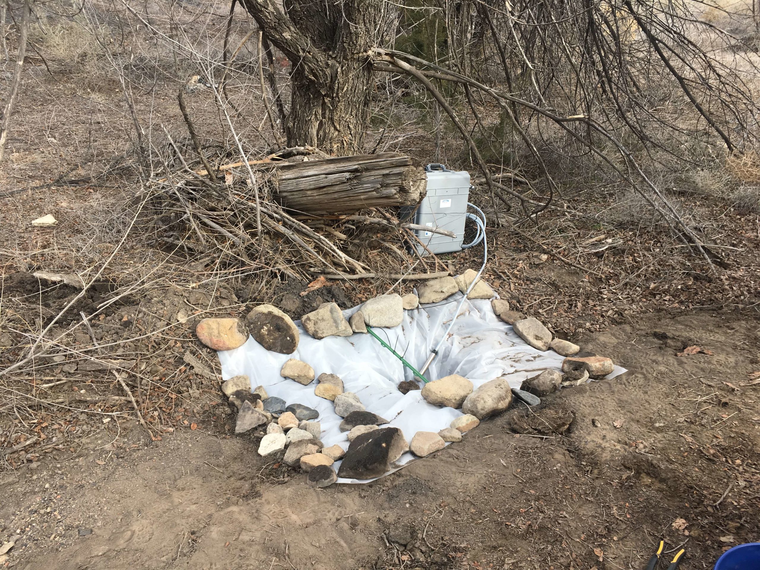
  • Land-Application Permitting: For facilities utilizing irrigation or surface-application as a disposal or reuse method, we monitor soil-water interactions to prevent nutrient loading and protect local groundwater.

  • Reuse Permit Coordination: We act as your primary liaison with state agencies like the WDEQ or CDPHE, helping to secure the specific authorizations needed to move water from a discharge point back into your operational cycle.

Why Professional Water Reuse Support is a Business Asset

In today’s regulatory climate, an efficient water cycle is a competitive advantage. By partnering with GMEC, you gain:

  1. Reduced Disposal Costs: Every gallon of water you reuse is a gallon you don’t have to pay to transport or inject into a disposal well.

  2. Regulatory Future-Proofing: By adopting advanced monitoring and reuse strategies now, you stay ahead of increasingly stringent discharge regulations and “zero-liquid-discharge” (ZLD) mandates.

  3. Operational Resilience: A secure, on-site supply of recycled water reduces your dependence on external water rights and protects your facility during drought-related curtailments.

The GMEC Difference

We don’t just “test the water”, we help you manage it. Our team combines technical chemical expertise with a practical understanding of the industrial and energy infrastructure of the West. We provide the clear data and professional opinions you need to turn your water challenges into a sustainable advantage.

Ready to ensure your project’s compliance?

Contact Grouse Mountain Environmental Consultants today for a consultation.
Learn more about our water resource services.

Stream & Riparian Area Assessments

Riparian Area & Stream Assessments

In the high-desert and mountain ecosystems of the West, the health of a stream is the ultimate indicator of the health of the land. A stable, functional riparian zone acts as a natural sponge, filtering pollutants, recharging aquifers, and providing critical corridors for wildlife and livestock alike. However, many of our regional waterways face pressure from historical land use, infrastructure development, and shifting climate patterns.

At Grouse Mountain Environmental Consultants, we specialize in Stream and Riparian Area Assessments. We provide the data-driven insights and design expertise needed to evaluate, monitor, and restore the vital “green ribbons” of the Mountain West.

The Rosgen Standard: Evaluating Stream Function

To fix a stream, you first have to understand its geometry. We utilize the industry-standard Rosgen Classification System to categorize stream types based on their slope, width-to-depth ratio, and bed material. This allows us to perform:

  • Proper Functioning Condition (PFC) Assessments: We determine if a stream is “functioning,” “functional-at-risk,” or “non-functional.” This qualitative assessment is a critical first step in prioritizing restoration dollars.

  • Geomorphic Stability Analysis: By understanding a stream’s natural “evolutionary” state, we can predict whether a channel is likely to remain stable or begin to “headcut” and erode during the next high-water event.

  • Reference Reach Identification: We identify healthy “reference” sections of similar streams to serve as the ecological blueprint for your restoration project.

Advanced Monitoring: AIM, MIM, & Biological Health

Long-term stewardship requires more than a single visit. We establish permanent stream-monitoring sites and utilize standardized federal protocols to track trends over time:

  • Aquatic Inventory & Monitoring (AIM): We provide the rigorous, quantitative data required for BLM and state land-management reporting, focusing on water quality, physical habitat, and biological integrity.

  • Multiple Indicator Monitoring (MIM): Specifically designed for grazing and riparian management, we track “stubble height,” “streambank stability,” and “woody species regeneration” to help land managers balance production with conservation.

  • Benthic & Invertebrate Sampling: The “bugs” tell the story. By sampling the macroinvertebrates living in the stream bed, we provide a biological “report card” of long-term water quality that chemical testing alone might miss.

From Assessment to Action: Stream-Restoration Design

An assessment is only as good as the solution it creates. We translate our field data into practical, buildable Stream-Restoration Designs:

  • Natural Channel Design: We use the land’s own geometry to create stable, self-sustaining channels that reduce erosion and improve sediment transport.

  • Riparian Revegetation: We design planting plans utilizing native willows, sedges, and cottonwoods to “armor” banks naturally and restore shade and habitat.

  • Structure Integration: Where necessary, we design “low-tech” process-based restorations (PBR) or engineered structures that mimic natural debris jams to slow water and trap sediment.

Why Professional Stream Assessment is a Business Asset

Whether you are a private rancher, a government agency, or an industrial developer, understanding your riparian assets is a strategic necessity. By partnering with GMEC, you gain:

  1. Defensible Management Data: Our AIM and MIM reports provide the scientific “proof of performance” needed to satisfy regulatory requirements and land-use permits.

  2. Infrastructure Protection: By identifying stream instability early, we help you protect bridges, roads, and pipelines from the catastrophic bank failures that occur during spring runoff.

  3. Successful Mitigation: If your project requires wetland or stream offsets, our Rosgen-based designs ensure your restoration meets the high “functional lift” standards required for credit release.

The GMEC Difference

We don’t just walk the banks; we understand the system. Our team combines technical hydrology with a deep-rooted knowledge of Western botany and geomorphology. We provide the clear, actionable data you need to manage your water resources for the next generation.

Ready to ensure your project’s compliance?

Contact Grouse Mountain Environmental Consultants today for a consultation.
Learn more about our water resource services.

Wetland Delineation & Mapping

Wetland Delineation/Mapping

In the high plains and mountain valleys of the West, water defines the landscape. However, for developers, energy companies, and landowners, the presence of water even ephemeral or seasonal can trigger a complex web of federal protections. Under the Clean Water Act (CWA), identifying the precise boundary between “upland” and “wetland” is a legal necessity that can dictate the footprint, timeline, and budget of an entire project.

At Grouse Mountain Environmental Consultants, we specialize in Wetland Delineation and Mapping. We provide the technical field expertise and regulatory clarity needed to navigate the U.S. Army Corps of Engineers (USACE) jurisdiction with confidence.

The Science of Siting: Delineation & Habitat Assessment

A professional wetland delineation is more than just identifying standing water. It is a multi-parameter evaluation of vegetation, soil, and hydrology. We provide the defensible data required for federal concurrence:

  • Jurisdictional Wetland Delineation: Our field scientists use the 1987 USACE Manual and regional supplements to map the “Ordinary High Water Mark” (OHWM) and wetland boundaries with sub-meter GPS accuracy.

  • Wetland Habitat Quality Assessments: Not all wetlands are created equal. We evaluate the biological “rank” of a system, helping regulators understand the ecological value of the area in question.

  • Riparian Ecosystem Function Evaluations: We analyze the health of “buffer zones” along streams and rivers, assessing their ability to filter sediment, stabilize banks, and provide critical wildlife corridors.

Navigating the Clean Water Act: Section 404 & 401 Permitting

If your project requires the discharge of “dredged or fill material” into a jurisdictional water, you need a permit. We manage the full administrative lifecycle of your Section 404 obligations:

  • Nationwide Permit (NWP) Compliance: Many utility, road, and energy projects fall under “expedited” Nationwide Permits. We ensure your project meets all “General Conditions,” allowing for a faster authorization process.

  • Individual Permit (IP) Support: For larger impacts, we lead the intensive Individual Permit process, including the “Alternatives Analysis” required to prove that impacts have been avoided and minimized to the maximum extent practicable.

  • Section 401 Water Quality Certification: We coordinate with state agencies (such as the WDEQ) to secure the necessary certifications proving that your federal permit won’t violate state water quality standards.

Why Professional Wetland Consulting is a Business Asset

In the world of federal permitting, an “unauthorized fill” is a mistake that can cost hundreds of thousands of dollars in fines and remediation. By partnering with GMEC, you gain:

  1. Avoidance & Minimization Strategy: The cheapest permit is the one you don’t need. We work with your engineers to “micro-site” infrastructure away from jurisdictional waters, potentially bypassing the 404 process entirely.

  2. Regulatory Concurrence: By submitting “audit-ready” delineation reports, we reduce the “Request for Information” (RFI) cycles and field-verification delays from the USACE.

  3. Defensible Project Boundaries: Our high-resolution GIS mapping provides a clear “source of truth” for your construction crews, ensuring they stay within the permitted work zone.

The GMEC Difference

We understand the unique “ephemeral” nature of Western waterways. Our team combines deep botanical knowledge with a practical understanding of the construction and energy industries. We don’t just find wetlands; we provide the strategies you need to build around them successfully.

Ready to ensure your project’s compliance?

Contact Grouse Mountain Environmental Consultants today for a consultation.
Learn more about our water resource services.

Hydrologic & Watershed Modeling

Watershed and Hydrologic Modeling

In the high-altitude basins and vast plains of the Mountain West, understanding the movement of water is the difference between a resilient project and a costly failure. Whether you are planning a new industrial site, restoring a degraded stream, or managing a municipal watershed, the ability to predict how water responds to snowmelt and extreme weather is a critical engineering and regulatory requirement.

At Grouse Mountain Environmental Consultants, we provide specialized Hydrologic and Watershed Modeling. We translate complex environmental data into the “master plans” needed to manage water resources safely, sustainably, and in full compliance with regional standards.

Watershed Master Planning: The “Big Picture” View

A single project site is always part of a larger system. Our watershed master planning services provide the comprehensive data needed to understand the cumulative impacts of land use and climate:

  • Integrated Watershed Modeling: We utilize advanced software to simulate the interaction between rainfall, soil infiltration, and runoff across thousands of acres.

  • Flow-Duration & Flood-Frequency Analyses: We calculate the mathematical probability of “100-year storms” and seasonal peak flows. This ensures that your bridges, culverts, and spillways are engineered for the reality of Western weather.

  • Master Plan Development: We identify the “critical nodes” in a watershed where intervention, such as detention basins or riparian buffers, will have the greatest impact on downstream water quality and flood risk.

Restoration & Mitigation: Healing the Land

When a stream has been impacted by historical land use or industrial activity, “nature” often needs a technical helping hand. We provide the hydrologic assessment needed for successful restoration:

  • Stream Restoration Design: We don’t just “fix” a bank; we redesign the stream’s geometry to handle its natural sediment and water load. This reduces long-term erosion and improves aquatic habitat.

  • Mitigation Banking Support: For projects requiring Clean Water Act (CWA) offsets, we provide the hydrologic data needed to prove that a restoration site will provide a self-sustaining, functional benefit.

  • Sediment Transport Modeling: We predict how changes in flow will move sediment, ensuring that restoration efforts don’t lead to unintended downstream “clogging” or upstream “scouring.”

Why Professional Hydrologic Modeling is a Business Asset

In the world of civil engineering and environmental permitting, “guessing” at water flow is a liability. By partnering with GMEC, you gain:

  1. Infrastructure Longevity: By designing for accurate flood frequencies, you prevent the washouts and structural failures that lead to emergency repairs and insurance claims.

  2. Regulatory Credibility: Our models are built to the standards of the USACE, FEMA, and state environmental agencies, providing a defensible record for your permit applications.

  3. Cost-Effective Design: Accurate modeling often reveals that “over-engineering” isn’t necessary in certain areas, allowing you to allocate your construction budget more efficiently.

The GMEC Difference

We combine the technical depth of a specialized hydrology firm with a practical understanding of the Mountain West’s topography. Our team knows that a successful model must reflect the unique “flashy” nature of our high-desert streams and the power of our spring runoff.

Ready to ensure your project’s compliance?

Contact Grouse Mountain Environmental Consultants today for a consultation.
Learn more about our water resource services.

Groundwater Permitting & Beneficial Use

groundwater permitting

In the Mountain West, water isn’t just a resource, it is a legal and operational lifeline. Whether you are developing a new industrial facility, managing a large-scale agricultural operation, or overseeing a municipal project, your access to groundwater is governed by a complex web of “first-in-time, first-in-right” priority dates and rigorous state standards. Securing a permit is only the first step; maintaining compliance and proving beneficial use is a lifelong commitment for any water right holder.

At Grouse Mountain Environmental Consultants, we provide specialized Groundwater Permitting and Beneficial Use Support. We bridge the gap between your project’s water needs and the strict requirements of state water regulatory authorities.

Securing Your Right: Water Appropriation & Groundwater Permitting

The process of “appropriating” water requires more than just drilling a well. It requires a defensible application that accounts for existing water users and the long-term health of the aquifer. We manage the administrative and technical lifecycle of your water rights:

  • Water Appropriation Permitting: We handle the full application process for new groundwater diversions, ensuring all technical specifications and intended use descriptions meet state engineer requirements.

  • Substitute Water Supply Plans (SWSP): For projects that may temporarily impact existing water rights, we develop robust SWSPs. These plans provide a “replacement” water source to ensure senior water right holders are not injured during your operations.

  • Beneficial-Use Evaluations: Under Western water law, you must “use it or lose it.” We conduct formal evaluations to document that your water is being applied to a recognized beneficial use, protecting your water right from abandonment or forfeiture.

The Science of the Aquifer: Modeling & Impact Assessment

To secure a permit in a “closed” or highly regulated basin, you must prove that your pumping won’t negatively impact the surrounding environment or neighboring wells. We provide the high-level hydrogeology needed for approval:

  • Groundwater Modeling: Utilizing industry-standard software, we create 3D models of subsurface flow. This allows us to predict “drawdown” cones and simulate how your pumping will behave over years or decades of operation.

  • Aquifer Impact Assessments: We evaluate the potential for “well interference” and assess whether your diversion could impact surface water features, such as springs or wetlands, ensuring your project remains compliant with environmental regulations.

  • Compliance with Regulatory Authorities: We act as your technical advocate with state agencies like the Wyoming State Engineer’s Office (SEO) or the Colorado Division of Water Resources, navigating the specific nuances of regional water law.

Why Professional Groundwater Support is a Business Essential

In the West, a project without a secure water right is a project at risk. By partnering with GMEC, you gain:

  1. Reduced Regulatory Risk: Our data-driven applications reduce the likelihood of protests from neighboring water users and “Requests for Information” from state regulators.

  2. Long-Term Asset Protection: By documenting beneficial use and performing regular aquifer health checks, we ensure your water rights remains a valuable, legally protected asset for the life of your project.

  3. Operational Certainty: Groundwater modeling allows you to design your well fields with precision, preventing premature well failure and ensuring a reliable supply for your operations.

The GMEC Difference

We understand the “law of the river” and the science of the aquifer. Our team combines technical hydrogeologic expertise with a deep-rooted understanding of the regulatory landscape in Wyoming and the surrounding states. We don’t just find water; we secure your right to use it.

Ready to ensure your project’s compliance?

Contact Grouse Mountain Environmental Consultants today for a consultation.
Learn more about our water resource services.

Laboratory Consultation & Water Data Management

Water Data Management

In environmental compliance, a water sample is only as valuable as the data it produces. However, the path from a field-collected vial to a defensible regulatory report is fraught with technical hurdles. Choosing the wrong analytical method, failing to account for “matrix interferences,” or losing track of historical trends can turn a routine monitoring event into a costly compliance nightmare.

At Grouse Mountain Environmental Consultants, we provide specialized Laboratory Consultation and Water Data Management. We ensure your water monitoring program is built on a foundation of technical precision, rigorous quality control, and actionable intelligence.

Strategic Laboratory Consultation: Choosing the Right Path

Not all laboratories or analytical methods are created equal. Depending on your specific permit requirements, the “standard” test might not be enough. We provide the expert guidance needed to navigate the complexities of environmental chemistry:

  • Constituent-Selection Advice: We help you identify the specific “parameters of concern” for your industry, ensuring you aren’t over-spending on unnecessary tests while still meeting all NPDES, WYPDES, or RCRA requirements.

  • Method Selection & Detection Limits: We coordinate with certified laboratories to select the appropriate analytical methods (e.g., EPA 6020 or 200.8) to ensure your detection limits are low enough to meet stringent water quality standards.

  • QA/QC Guidance: We develop and oversee Quality Assurance/Quality Control protocols, including the use of field blanks, duplicates, and matrix spikes, to ensure your data is scientifically valid and legally defensible.

The Power of Precision: Advanced Water Data Management

For facilities with decades of monitoring history or dozens of sampling points, a spreadsheet is no longer enough. We transform raw laboratory results into a strategic asset:

  • Proprietary Water-Monitoring Databases: we develop custom, secure databases tailored to your facility’s specific footprint. This ensures all your historical data is centralized, searchable, and audit-ready.

  • Trend-Analysis Tools: We utilize advanced statistical tools to identify “upgradient vs. downgradient” relationships and long-term “trending” of constituents. This allows for early detection of potential impacts before they trigger a permit exceedance.

  • Client-Specific Reporting: We translate complex chemical data into clear, visual reports. From “Piper Diagrams” and “Stiff Patterns” to automated compliance summaries, we give you the tools to communicate status clearly to stakeholders and regulators.

Why Professional Data Management is a Business Essential

In environmental management, data is your best defense and your most valuable planning tool. By partnering with GMEC, you gain:

  1. Reduced Analytical Costs: By optimizing your constituent lists and sampling frequencies, we ensure your laboratory budget is focused on what truly matters for your permit.

  2. Regulatory Confidence: Our rigorous QA/QC oversight means that when a regulator audits your files, they find a complete, transparent, and technically sound administrative record.

  3. Proactive Risk Mitigation: Trend analysis allows you to “see around the corner,” identifying equipment failures or liner leaks in their infancy, potentially saving millions in future remediation costs.

The GMEC Difference

We aren’t just “sample takers”; we are data stewards. Our team understands the industrial and energy infrastructure of the West and the high-stakes nature of water quality reporting. We provide the technical depth of a national laboratory consultant with the personalized service and local knowledge of a regional partner.

Ready to ensure your project’s compliance?

Contact Grouse Mountain Environmental Consultants today for a consultation.
Learn more about our water monitoring services.

Strategic Sediment & Erosion Sampling for Watershed Health

Sediment Sampling

In the Mountain West, sediment is the most common pollutant in our waterways. Whether it is driven by large-scale agricultural operations, industrial land disturbance, or natural watershed destabilization, excess sediment does more than just turn a stream cloudy. It alters aquatic habitats, reduces reservoir capacity, and can serve as a carrier for other regulated pollutants. For land managers and industrial operators, understanding the “sediment story” of a site is a critical part of long-term environmental stewardship.

At Grouse Mountain Environmental Consultants, we provide specialized Sediment and Erosion Sampling. We design and implement the data-driven programs needed to quantify sediment loads and protect the integrity of our regional watersheds.

Quantifying the Load: Erosion Studies & Watershed Assessments

Erosion isn’t just a surface-level problem; it’s a volumetric one. We provide the technical field expertise to measure the impact of land use on water quality:

  • Agricultural & Industrial Erosion Studies: We perform site-specific evaluations to determine how runoff from tilled fields or construction sites is contributing to local sediment loads.

  • Watershed-Scale Assessments: Sediment issues rarely stop at the property line. We look at the “big picture,” assessing how cumulative upstream activities are impacting the stability and water quality of an entire drainage basin.

  • Turbidity & Total Suspended Solids (TSS): We utilize high-precision field meters and laboratory analysis to correlate visual water clarity (turbidity) with the actual mass of sediment (TSS) moving through the system.

Designing Programs for Watershed Stability

A single “grab sample” after a rain event doesn’t provide a complete picture. Effective sediment management requires a program designed to capture the variability of the Western climate:

  • Sediment Load Evaluation: We design sampling schedules that account for “pulse” events such as spring snowmelt or intense summer monsoons to calculate the total annual sediment yield of a site.

  • Watershed Destabilization Identification: We identify the “geomorphic red flags,” such as head cutting, bank slumping, or loss of riparian vegetation, that indicate a system is reaching a tipping point of instability.

  • Erosion Control Efficacy: Are your BMPs (Best Management Practices) actually working? We provide the “before and after” sampling data needed to prove that your silt fences, basins, and reclamation efforts are effectively keeping sediment out of the water.

Why Professional Sediment Sampling is a Business Asset

In the world of environmental permitting and land management, data is your best defense. By partnering with GMEC, you gain:

  1. Regulatory Defensibility: Our sampling protocols meet state and federal standards, providing a robust record that protects you from claims of “unauthorized discharge” or downstream impact.

  2. Targeted Mitigation: By identifying exactly where the sediment is entering the system, we help you spend your reclamation and erosion-control budget more effectively.

  3. Resource Protection: Accurate sediment data allows for better management of irrigation infrastructure, livestock watering points, and industrial intake systems, reducing long-term maintenance costs.

The GMEC Difference

We don’t just measure mud; we analyze the health of the landscape. Our team combines technical hydrology with a deep understanding of the agricultural and industrial heritage of Wyoming and the surrounding states. We provide the clear, actionable data you need to manage your land and water resources sustainably.

Ready to ensure your project’s compliance?

Contact Grouse Mountain Environmental Consultants today for a consultation.
Learn more about our water monitoring services.

Strategic Ground & Surface Water Quality Monitoring

water quality monitoring

In the industrial and energy sectors of the Mountain West, water is a critical operational component and a high-stakes regulatory responsibility. Whether you are managing produced water in the oil field, discharge from a manufacturing facility, or a large-scale land-application system, the “right to operate” depends on the quality of your data. A single missed sample or a skewed laboratory result can lead to costly “Notices of Violation” and project delays.

At Grouse Mountain Environmental Consultants, we provide specialized Ground and Surface Water Quality Monitoring. we bridge the gap between your operational goals and the rigorous standards of state and federal discharge permits.

Permit Issuance & Water Quality Monitoring

Before a drop of water is discharged, the regulatory framework must be in place. We provide the technical foundation for your permit lifecycle:

  • Discharge Permit Issuance: We assist in the characterization and documentation needed for NPDES or WYPDES permit applications, ensuring your discharge limits are both protective and operationally achievable.

  • Routine Compliance Sampling: Our field technicians perform the systematic sampling of effluent and receiving waters required by your permit, utilizing strict “Chain of Custody” protocols to ensure every data point is defensible.

  • Effluent & Land-Application Support: For facilities utilizing land-application or water-reuse systems, we monitor soil and water interactions to prevent long-term nutrient loading or soil degradation.

Energy Sector Support: Produced Water & Pit Permitting

In the energy-rich basins of Wyoming and the surrounding states, managing produced water is a primary logistical challenge. We provide the specialized oversight needed for:

  • Produced Water-Pit Permitting: We manage the hydrogeologic investigations and application preparation for produced water disposal pits, ensuring they meet state-specific liner and monitoring requirements.

  • Baseline-Quality Programs: Before a new project begins, we establish a robust “baseline” of existing water quality. This is your best insurance policy against future claims of environmental impact.

  • Long-Term Trending & Analysis: We don’t just collect samples; we analyze the trends. Our team identifies subtle changes in water chemistry over time, allowing for “course corrections” before they become a compliance issue.

Water Reuse & Sustainable Management

As water scarcity increases, the ability to safely reuse water is a major competitive advantage. We provide the monitoring and permitting support needed to turn a “waste stream” into a “resource”:

  • Water-Reuse Sampling: We provide the high-frequency testing needed to ensure reused water meets the specific safety standards for its intended new purpose.

  • Regulatory Coordination: We act as your technical liaison with agencies like the WDEQ or CDPHE, helping to navigate the evolving frameworks for industrial water recycling.

Why Professional Water Monitoring is a Business Essential

In environmental compliance, what you don’t know can hurt your bottom line. By partnering with GMEC, you gain:

  1. Legal Defensibility: Our sampling protocols meet or exceed EPA standards, providing a robust administrative record that protects your facility during agency audits.

  2. Operational Insights: Detailed water quality data allows you to optimize your treatment processes, potentially reducing chemical costs and improving system efficiency.

  3. Proactive Risk Management: By identifying “trending” contaminants early, we help you address issues before they trigger a permit exceedance or require expensive remediation.

The GMEC Difference

We know Western water. Our team combines technical field expertise with a deep understanding of the industrial and energy infrastructure unique to our region. We provide the clear data and professional opinions you need to manage your water resources with confidence.

Ready to ensure your project’s compliance?

Contact Grouse Mountain Environmental Consultants today for a consultation.
Learn more about our water monitoring services.

GET IN TOUCH

You can find us in the office weekdays from 8am-5pm or call anytime.

P: 307.684.2112

Grouse Mountain Headquarters

760 West Fetterman Street
Buffalo, WY 82834

Grouse Mountain New Mexico

3600 Cerrillos Rd, Ste 407
Santa Fe, NM 87507

Send us a message or inquire on your next project.

  • This field is for validation purposes and should be left unchanged.